-
 A heat dome continues to leave Florida under Heat Advisories through this evening.
 -
 Saharan dust is in place, and a high pressure will continue to bring dangerous heat across much of Florida throughout the weekend.
 -
 During any heat wave, it is more important than ever to keep in mind beach and pool safety tips for children, adults, and even pets.
 -
 A strengthening El Niño over the Pacific Ocean may be already influencing Florida's weather, with long-range outlooks indicating a return to below-average rainfall.
 -
 Colorado State University released their updated predictions for the 2026 hurricane season. However, they expect even fewer named storms compared to their last forecast in June.
 -
 Florida finished June as one of its 10 warmest on record despite cooler conditions in parts of the state. Forecasters are now tracking another prolonged stretch of dangerous heat.
 -
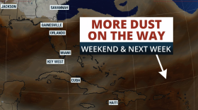
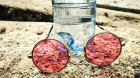
 A plume of Saharan dust is set to arrive to Florida, causing the storm chances to drop and temperatures to soar. Let's talk about the dust!
 -
 Males and Florida lead the nation in lightning fatalities. Here are some lightning safety tips.
 -
 As Americans prepare to celebrate the nation's 250th birthday, weather records kept by Thomas Jefferson offer a fascinating glimpse into the conditions surrounding the adoption of the Declaration of Independence—and reveal how weather has helped shape America from the very beginning.
 -
 Florida will not be setting new hot records, but it will be extremely humid, and the temperatures will feel above 100 F every afternoon throughout the holiday weekend. How about the rain? There are some marine hazards too!

© 2026 | WUWF Public Media
11000 University Parkway
Pensacola, FL 32514
850 474-2787
11000 University Parkway
Pensacola, FL 32514
850 474-2787
Play Live Radio
Next Up:
0:00
0:00
Available On Air Stations


