-
 Tropical Storm Bertha made landfall north of the mouth of the Mississippi River on Wednesday. The threat for dangerous rip currents was expected to continue along the Gulf Coast.
 -
 The Peninsula had drier-than-usual conditions as Bertha was west of the state. The wind also left less hot afternoons across the western portion of the Peninsula, but as we wave goodbye to Bertha, rain and heat return to Florida. Let's look at this week's forecast.
 -
 Tropical Storm Bertha is producing dangerous surf and life-threatening rip currents for beaches along Florida's Panhandle.
 -
 Tropical Storm Bertha slowly drifts west-northwest across the northeastern Gulf of Mexico toward southeastern Louisiana. While strong wind shear is expected to limit rapid intensification, Bertha will bring prolonged tropical-storm-force winds, storm surge, and heavy rainfall to portions of the Florida Panhandle, the central Gulf Coast, and southern Louisiana through midweek.
 -
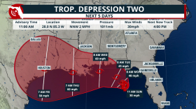 Tropical Depression 2 is set to become Tropical Storm Bertha as it travels mainly due west during the next few days. Gulf waters are warm and could strengthen this system if it stays well away from the Gulf Coast.
 -
 The Florida Keys are considered the waterspout capital of the world, producing hundreds each year. But not all waterspouts form the same way. Here's how to tell the difference between fair-weather and tornadic waterspouts—and why it matters for your safety.
 -
 Rounds of heavy rain will impact parts of Central and North Florida due to a potential tropical system. Mixed signals on where it could go and intensity.
 -
 Florida's meteorological summer is at its halfway point. So far, the 2026 season has produced above-average warmth and varying amounts of precipitation.
 -
 Heat doesn't just make you sweat—it can affect your brain, your sleep, your decision-making, and even become deadly long before many people realize they're in trouble. Here are five more hidden heat dangers every Floridian should know.
 -
 Florida's heat is about much more than high temperatures. In Part 1 of this two-part series, AccuWeather explains what heat is actually doing to your body—and why some of the earliest warning signs are often the easiest to miss.

© 2026 | WUWF Public Media
11000 University Parkway
Pensacola, FL 32514
850 474-2787
11000 University Parkway
Pensacola, FL 32514
850 474-2787
Play Live Radio
Next Up:
0:00
0:00
Available On Air Stations


