With no further storms expected, the Atlantic hurricane season is ending on a quiet note, marked by records for both its inactivity and the power it unleashed.
The basin produced a near-average number of named storms, a below-average amount of hurricanes and a number of major hurricanes - including Hurricane Melissa, the most intense landfalling cyclone ever observed in the Atlantic basin during modern times.
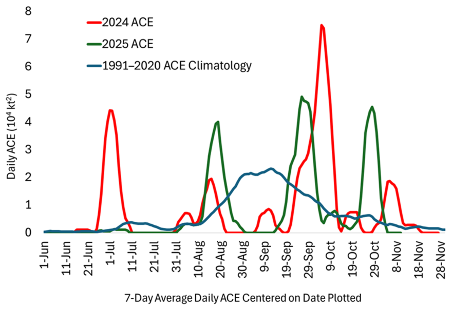
According to NOAA’s classification, the year was considered an above-normal season based on Accumulated Cyclone Energy (ACE), a metric that tallies storm intensity and longevity.
Dr. Phil Klotzbach, a world-renowned hurricane specialist at Colorado State University, said the tropical season was dominated by conflicting signals.
Warm Atlantic waters combined with neutral to weak La Niña conditions typically make the basin more favorable for hurricane activity, yet the heart of the season, from late August through mid-September, produced minimal activity.
“The lull was likely due to a combination of factors, including a dry and stable tropical Atlantic, pronounced upper-tropospheric trough activity that increased vertical wind shear, and sinking motion over Africa that suppressed West African precipitation and likely easterly wave (e.g., TC seed) amplitude,” Klotzbach stated in a season summary.
In total, only five hurricanes formed in the Atlantic - the fewest in a single season since 2015, when four hurricanes developed.
The number of expected cyclones finished below preseason projections from CSU, which had predicted 17 named storms, nine hurricanes and four major hurricanes.
The season ultimately produced 13 named storms, five hurricanes and four major hurricanes, with the first forming in June and the last cyclone in October.
Despite the miss on the number of cyclones, Klotzbach said the outlook was far from a bust - especially when judged by ACE, which synthesizes sustained wind speeds and storm duration into a single value.
Before the 2025 season began, CSU projected an ACE value of 155 and later adjusted it downward to 140 units in an early-season update.
The basin finished with an ACE value of around 133, fueled largely by Hurricanes Melissa, Erin, Humberto and Gabrielle.
“Our ACE forecasts for 2025 ended up verifying pretty well,” said Klotzbach.
But what stood out most, Klotzbach added, was when storms formed and when they didn’t.
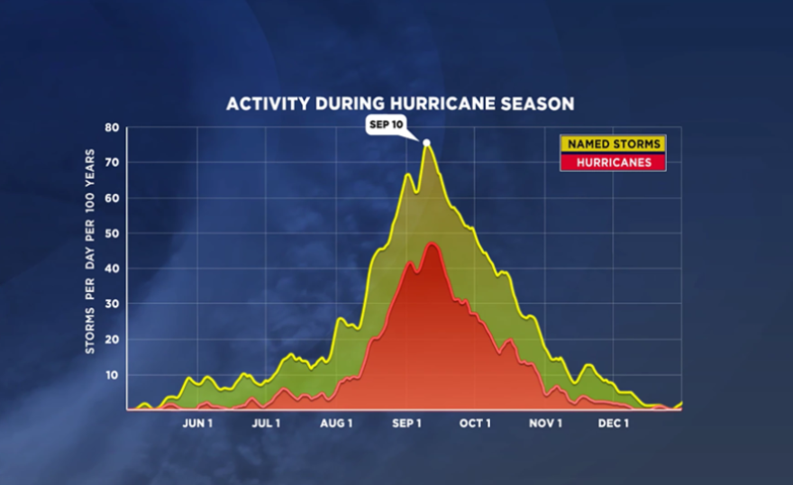
For the third time in four years, the climatological heart of hurricane season failed to deliver its typical surge of cyclones.

Historic late-summer, early-fall lull
The stretch from around Aug. 22 through Sept. 20 produced zero hurricanes, a rare occurrence in records dating back to the mid-20th century.
According to the CSU team, the last time the Atlantic went without a hurricane during that five-week period was 1956.
But the quiet mid-peak-season period has become a notable theme in recent years.
The 2022 hurricane season produced zero cyclones in August, and the 2024 season featured the quietest peak in more than 50 years.
Still, Klotzbach cautioned against drawing long-term conclusions and said many more years of data will be needed to determine whether a trend is underway.
“I think it’s too early to say if this is a trend, given that 2020, 2021 and 2023 all had extremely healthy climatological peak seasons,” said Klotzbach.
Typically, during the period between Aug. 20 and Sept. 20, five named storms form, with three of them strengthening into hurricanes with winds of at least 74 mph.
Without the primetime weeks being active, there is little a season can do to make up for any shortfalls, as atmospheric conditions widely start to become hostile by late October.

U.S. spared from significant impacts in 2025
While parts of the Caribbean suffered the worst impacts, the continental United States experienced one of its most uneventful hurricane seasons in years.
Only one system - Tropical Storm Chantal - made landfall in the U.S., impacting the South Carolina coast between Charleston and Myrtle Beach on July 6.
Chantal formed from a decaying frontal boundary and remained weak throughout its short lifespan.
Most of the impacts were tied to heavy rainfall, with radar estimating 4 to 6 inches across portions of South Carolina’s Grand Strand.
Besides Chantal, no other tropical storms or hurricanes struck the U.S. coastline - a scenario that has not happened since 2015.

Hurricane Melissa: A record-setting disaster
While Melissa was never a direct threat to the Lower 48 U.S., other parts of the basin saw devastating impacts.
Jamaica, Cuba and Haiti endured the full force of Hurricane Melissa, with destructive winds and flooding rains and landslides.
Melissa formed on Oct. 21 from a disturbance that was able to break through the hostile atmospheric conditions in the Caribbean Sea.
Once over water temperatures in the range of 84 to 88 degrees, the cyclone rapidly intensified into a Category 5 on the Saffir-Simpson Hurricane Wind Scale.
Those warm waters allowed Melissa to sustain Category 5 strength while making landfall in Jamaica, and the cyclone maintained Category 3 strength as it impacted nearby Cuba.

During its trek, Melissa broke or tied multiple records:
- Highest wind gust ever recorded by a dropsonde: 252 mph
- Tied for strongest Atlantic hurricane landfall winds: 185 mph
- Tied for lowest landfall pressure: 892 millibars
- Most powerful hurricane on record to strike Jamaica
For the Caribbean islands, the damage left in its wake was staggering.
According to the United Nations Office for the Coordination of Humanitarian Affairs, the major hurricane left at least 100 dead or missing, with damage estimates in the billions of dollars.
Undoubtedly, the hurricane’s name will be up for discussion for retirement at the World Meteorological Organization’s annual springtime meeting.
Looking ahead to the 2026 hurricane season
While the next hurricane season is nearly 200 days away, it isn’t stopping hurricane experts from looking ahead.
After two years of outlooks that hinted at more tropical activity than what actually occurred, there could be some changes made during the offseason.
“I do anticipate more significant changes to our statistical/dynamical models for 2026, given they’ve been far too aggressive the past couple of years. I’m going to look at switching to taking the models’ forecasts of vertical wind shear instead of SST [sea surface temperature],” Klotzbach stated.
Additionally, Klotzbach said the European Centre for Medium-Range Weather Forecasts is planning a major upgrade to its model, which could impact computer systems that base their forecasts off of ECMWF guidance.
If there are no off-season cyclone developments, the 2026 season will begin on June 1, with the first seasonal outlook released by CSU in early April.
The first name of the 2026 hurricane season will be Arthur, followed by Bertha, Cristobal and Dolly.
If the stretch of names sounds familiar, it is because the list was previously used in 2020 and is one six rotating lists maintained by the WMO.
A name that was on the 2020 list that won't be repeated again in the Atlantic is "Laura.”
Laura was retired after it struck Louisiana as a Category 4 hurricane and was replaced by "Leah," which will be used for the first time during the upcoming season.


