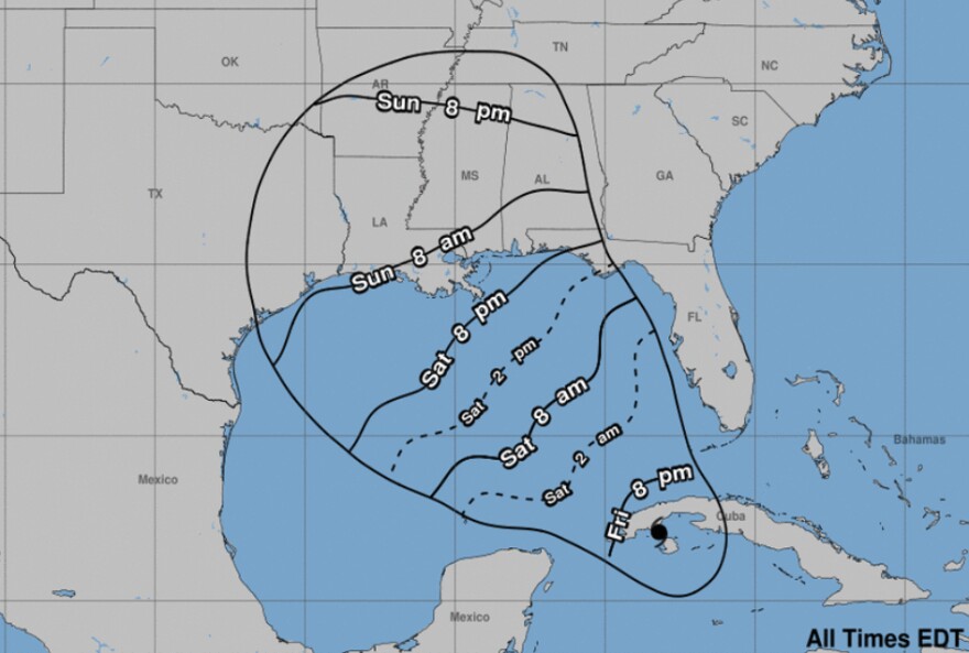
Forecasters say Ida could be at least a major hurricane, with top winds of 120 mph, when it nears the U.S. Gulf Coast. This as residents in the Florida Panhandle are being urged to keep tabs on her.
Ida became a Category-1 hurricane early Friday afternoon, with top sustained speeds of 75 miles an hour. Movement is northwest at about 15 miles an hour.
“[Friday afternoon] the storm was over the western Caribbean and it’s going to be passing over the western tip of Cuba [Friday] night and into the Gulf of Mexico on Saturday,” said Ray Hawthorne, a meteorologist at the Florida Public Radio Emergency Network.
Ida’s projected path, he says, is fairly well in sync with forecast models.
“[The] steering in the atmosphere is well-defined; it appears that the center of Ida is going to be making landfall sometime Sunday,” Hawthorne said. “Most likely Sunday afternoon along the coast of Louisiana, and that’s where the most severe impacts are likely be from this storm.”
Sunday is the 16th anniversary of perhaps the most devastating storm to hit the Pelican State – Hurricane Katrina. Ida, on the way across the Gulf of Mexico, will encounter some of the warmest waters in the Gulf – the ideal “fuel” for strengthening.
“And the water is quite warm quite a ways down below the ocean’s surface by as much as 120 to 150 feet deep,” said Hawthorne. “That, combined with very light winds high in the atmosphere and high relative humidity values around the storm itself, strongly favor this becoming a major hurricane.”
The official forecast from the National Hurricane Center has Ida going to a Category-3 storm before landfall on Sunday. And it’s possible it can get stronger and become a Cat-4. FPREN’s Ray Hawthorne advises those in Northwest Florida to expect some type of impact, including heavy rainfall.
“We’re looking at fringe bands, and those fringe bands are likely to come onshore Sunday morning; and they’ll be off-and-on during the day on Sunday and most likely lasting into Monday,” said Hawthorne. “So over a two-day period, most areas could see 5-6 in. of rainfall. There is the risk for isolated, brief tornadoes Sunday or Monday.”
If you’re planning a trip to the beach this weekend, bring a book and forego going into the water.
“The Gulf is going to be rough; we’re looking for rip currents, and also there may be some coastal flooding near the time of high tide,” Hawthorn said. “In the Pensacola area, the high-tide times are actually just prior to sunrise. So if there’s going to be coastal flooding, it will likely be late at night and early in the morning – both on Sunday and Monday.”
Louisiana Gov. John Bel Edwards has declared an emergency for the entire state, and officials are ordering mandatory evacuations along the coast. Closer to home, sandbags and sand are available in Okaloosa, Santa Rosa and Escambia Counties. More information is at the counties’ websites.

