Update Thursday March 18, 2021 at 12:10AM EDT: A Tornado Watch has been issued for parts of the western and central Florida Panhandle until 6AM CDT (7AM EDT). This includes the cities of Pensacola, Destin, Crestview ,and Panama City.
A line of strong thunderstorms was located just to the west of Escambia County near midnight Thursday. This line is continuing to move quickly northeastward at about 60 mph and should be entering into the western Florida Panhandle between 2AM and 4AM CDT.
These storms will have the capability of producing tornadoes overnight and into Thursday morning for the warned area. Make sure that you have multiple ways to receive weather warnings throughout the rest of tonight and through Thursday.Update Wednesday March 17, 2021 10:00PM EDT: A formidable cold front is expected to move into western portions of the Florida Panhandle overnight into Thursday before entering into the Peninsula Thursday afternoon.
A formidable cold front is expected to move into western portions of the Florida Panhandle overnight into Thursday before entering into the Peninsula Thursday afternoon.
A strong low pressure system over the central Mississippi Valley and its associated cold front, extending south into the western Gulf of Mexico, was producing a significant outbreak of tornadoes, damaging winds, and hail over parts of Alabama, Mississippi and Georgia Wednesday. The Storm Prediction Center (SPC) Wednesday issued the maximum hazard alert-- a High Risk-- for a large portion of central Mississippi and Alabama. Numerous strong and a few long-track, potentially violent tornadoes, are expected to continue into the overnight Wednesday with the threat shifting into eastern Alabama and Georgia towards the morning Thursday.
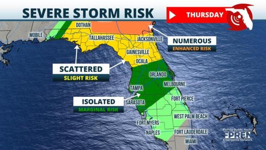
The overnight risk extends southward to encompass parts of the western Florida Panhandle. Latest model runs from the SPC have northwestern parts of the Panhandle in an Enhanced Risk (hazard level 3 out of 5). The cities of Pensacola and Crestview are close to the Enhanced outlined area. A Slight Risk (hazard level 2 out of 5) extends eastwards through the Panama City area and to the west of the Apalachicola National Forest.
The cold front, which will continue to produce a line of strong to severe thunderstorms ahead of it, is expected to approach the western Panhandle during the early morning hours Thursday between 3 and 6 am EST. The line should then continue eastward approaching Panama City around mid-morning Thursday and then the Tallahassee region by late morning or early afternoon.

The SPC has extended the Slight Risk area Thursday to include Panama City and eastward through the First Coast. Locations close to the Georgia border will be near an Enhanced Risk zone (hazard level 3 out of 5) outlined by the SPC and thus have a greater chance of experiencing stronger storms throughout Thursday.
Showers and thunderstorms are likely to be crossing into parts of North Florida through the afternoon and early evening before exiting into the Atlantic. The line of showers and thunderstorms will likely begin to degrade and become broken throughout the course of the afternoon and evening but a few thunderstorms could still become strong to severe, producing damaging wind gusts and the chance of a few isolated tornadoes.
The cold front will continue to steadily degrade Thursday night as it progresses southeastward into Central Florida where a Marginal Risk continues to be in place (hazard level 1 out of 5). A few storms could still reach severe levels but the threats will begin to minimize. South Florida will experience the remains of this cold front beginning Friday morning, which at that point should be weak. Scattered showers and thunderstorms possible in the morning and afternoon before the front clears the Sunshine State completely towards the evening Friday.
Here are the estimated times of arrival for storms across Florida:
- Pensacola, Destin, Crestview areas: 2-5 AM CDT
- Panama City, Marianna: 5-8 AM CDT
- Tallahassee, Apalachicola: 9 AM - Noon EDT
- Live Oak, Lake City, Perry: Noon - 3 PM EDT
- Jacksonville metro, Gainesville, Nature Coast: 3-6 PM EDT
- Tampa/St Pete, Orlando, Daytona Beach: 6-10 PM EDT
- Melbourne, Treasure Coast, Sarasota, Fort Myers: 10 PM Thursday - 5 AM Friday EDT
- Gold Coast and Keys: 5-11 AM Friday EDT
Copyright 2021 WUFT 89.1. To see more, visit WUFT 89.1. 9(MDAxODMzNjEzMDEyMTY4MzMwNzBiMGMyYQ004))

