-
 Sub freezing lows are forecasted for the Panhandle and North Florida on Wednesday morning. Wind chills in the 30s are expected as far south as Tampa and Orlando.
 -
 Just days after strong storms and numerous tornadoes across the Panhandle, the risk for severe thunderstorms returns
 -
 A severe weather system tracked across the Southeast this morning, and it spawned reports of tornadoes and damaging wind gusts across Florida’s Panhandle.
 -
 A severe weather system tracked across the Southeast this morning, and it spawned reports of tornadoes and damaging wind gusts across Florida’s Panhandle.
 -
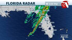
 The same system that produced damaging winds and tornado reports is entering the Florida peninsula this afternoon. Impacts to continue into the evening.
 -
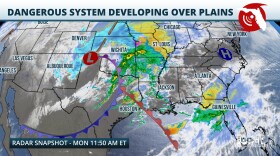 Multiple rounds of dangerous thunderstorms are expected as another strong winter storm barrels across the country. Damaging winds and a few tornadoes (potentially strong) are possible, especially over the Panhandle and North Florida.
 -
 While Florida is known for its generally mild winters compared to many other parts of the country, winter weather, including sub-freezing temperatures, freezing rain, and even snow, are possible over parts of the state.
 -
 Floridians may not be wearing mittens and scarfs this Christmas. A frontal system moving through will increase chances for showers and thunderstorms on Sunday and Monday for much of the state.
 -
 Strong winds and 3-5 inches of rainfall are possible across most of the state this weekend. Before the main storm arrives, conditions to remain windy on Friday.
 -
 Weather patterns are changing entering the winter season, and this could continue to bring wetter conditions to the Southeast.

© 2024 | WUWF Public Media
11000 University Parkway
Pensacola, FL 32514
850 474-2787
11000 University Parkway
Pensacola, FL 32514
850 474-2787
NPR for Florida's Great Northwest
Play Live Radio
Next Up:
0:00
0:00
Available On Air Stations


